
by Katrina Dewar, Field Scientist, Madagascar
This was my first introduction to the lives of the Blue Forests team – finally I got to go on an adventure with them! For a whole week we worked on developing resource use maps for seven different villages within the Bay of Assassins, named (among many other legends) for its treacherous breakwater known to swallow ships whole on their way into the bay. Despite its name, the Bay of Assassins is a gloriously bountiful area, full of mangroves, situated adjacent to the beautiful and threatened spiny forest ecoregion. It is home to our seaweed and sea cucumber aquaculture projects, located about an hour’s boat ride south of Andavadoaka, Blue Ventures’ main field site in southwest Madagascar.
Our mission was to map out current and past areas used for resource extraction throughout the Bay of Assassins in order to provide a baseline from which to improve our understanding of what, how, where and when natural resources are being used, and by whom. Ultimately, our hand-made maps and questionnaires, combined, will be used as tools for future management and conservation considerations in this area.
It was early on a misty morning in late October that we departed Andavadoaka, and arrived in the village of Tampolove for our preliminary training sessions with Community-Based Facilitators (CBFs). We got on with our first task upon arrival – readying the maps with scissors, glue, sticky tape and lots of patience! By the end of our arts and crafts session we had created more than 40 large maps (each comprising four A4 sized pages stuck together), just in time for the arrival of our four CBFs, who each travelled from a different village within Velondriake to help us with the mapping. And so began the training… The questionnaires were broken down and clarified, question by question to ensure that nothing had been lost in translation and that everyone was clear on the desired outcomes. This was then followed by an interactive practice mapping session using our pre-determined keys and colours to indicate different species and different user groups.
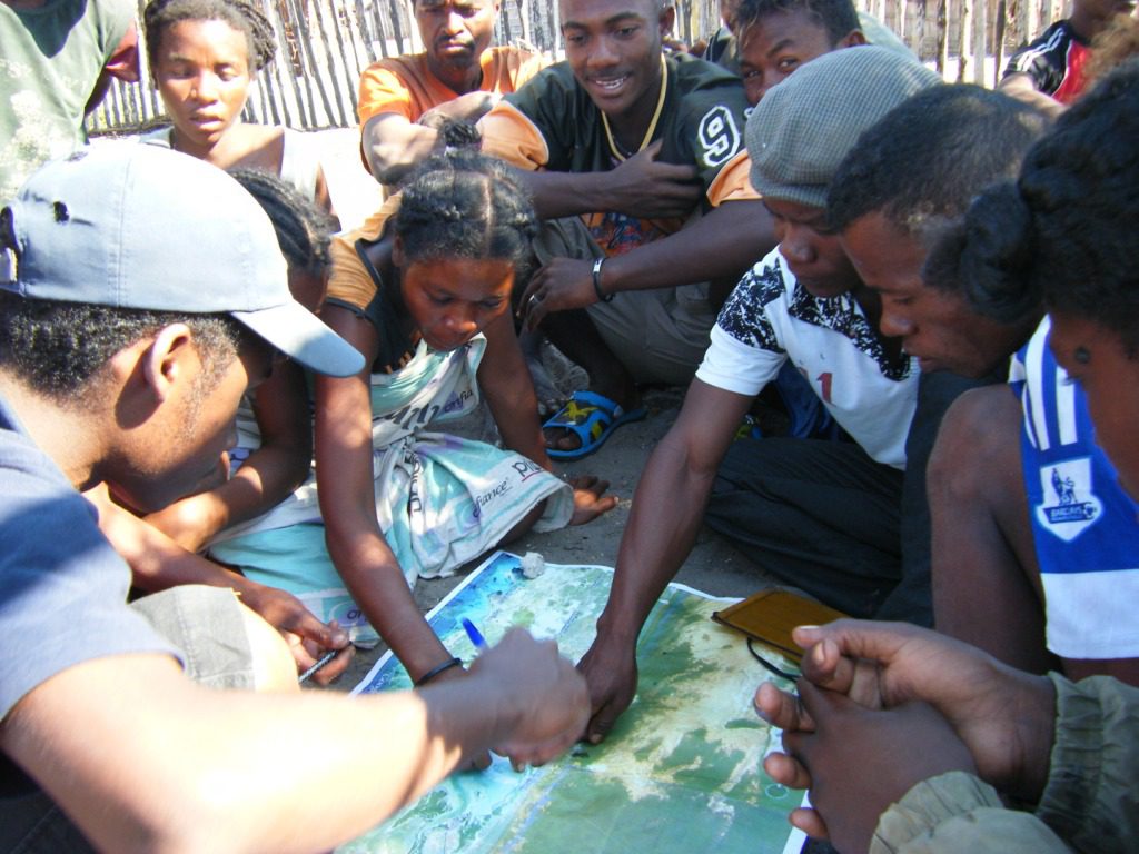
The communities of the Bay of Assassins were very engaged in the mapping process
From a training point of view, the process was not entirely straightforward as the focus of this expedition was not restricted to mangroves alone, but also aimed at other ecosystems, including other intertidal areas, farming plots, the dry terrestrial forest to the east, the seagrass beds of the inner bay, and the shallow fringing reef systems to the west. As all of these ecosystems are linked, resource use and extraction in one area can have dramatic impacts on another, therefore this mapping was an opportunity to consider mangroves as part of the interconnected ecosystem of the bay and also to provide us with a real insight of exactly what is happening, where. In order to achieve this, each respective community was going to be asked to divide into stakeholder groups: fishers, farmers, loggers, elders, lime-makers, fuelwood collectors, and charcoal producers, with each group allocated their own map, questionnaires, and at least one CBF to guide them through the process.
Once divided, the aim was then to ask each group to draw on their map where they go to do each activity; for example, fishers were expected to exert effort in different locations depending on their target species. Within this section they were also going to be asked to differentiate between areas of current use, previously visited spots, and areas used by other villages. To complement each map, the tailored questionnaires prepared for each stakeholder group were aimed primarily at determining, among other things, the frequency of the specific resource extraction as well as the estimated state and trend of that resource over the last 10 years.
Overall, the different requirements for each type of stakeholder group, rendered it a slightly challenging process from a training perspective, however, by the end of a long couple of days, we had a group of fully trained CBFs raring to go!
Possibly our most exciting journey came the third day (our first day of actual mapping) with a two-hour zebu cart ride (bum-bruising stuff) to Andalambezo village, located slightly inland, and thus not accessible by boat. Not only was this journey a source of many bruises but it also caused much hilarity as we somehow wound up dangerously close to submersion whilst trying to cross the mangroves. Having set out thinking our dry bags were a bit superfluous for this ‘inland’ trip, we were rather glad of them at that point!
It was already hot by the time we arrived at 8am, and we all huddled into the shade cast by a small wooden gazebo-like shelter near the village President’s house. The first day of real community mapping went well, with many people turning up to take part, despite our slightly delayed arrival (zebu, or perhaps their drivers, are apparently not fans of 4am departures and so we were limited to a 6am start).
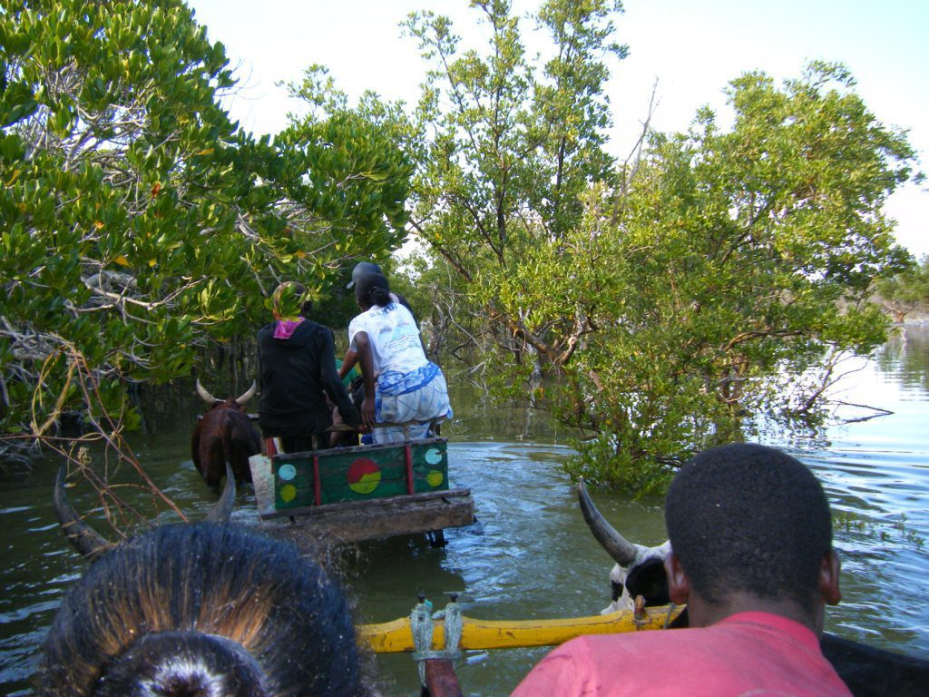
The team came close to swimming on a few occasions during the journey
It was brilliant to see how much interest was taken by each person involved in the process, with community members taking turns drawing out areas on the maps once a consensus was reached among the whole group, after partaking in active debate as to which areas were used for what, and by whom. It was a truly participatory process, with equal contributions from both men and women across all stakeholder groups. Pausing only for lunch and a kelikely (meaning small in Malagasy) nap, as is obligatory in the heat of the day; a makeshift gong, comprised of a piece of hanging metal, was then struck to gather everyone together again and thus we continued our session into the afternoon.
The red sun disappeared rapidly beyond the horizon as we finished up the maps. To round off the day’s events, the team presented some cartoon illustrations depicting a random sequence of mangrove uses and consequences and asked people to make up their own interpretation of which sequence of events they thought caused which results. Clearly, no one understands this better than resource-dependent communities like these communities in the Bay of Assassins, with the sessions resulting in interesting debates over the causes of forest loss, and discussions of the importance of protecting mangroves. Finally a mangrove quiz, complete with prizes, got everyone excited and the general levels of local knowledge shared regarding mangroves was impressive.
The remaining days flew by in a similar fashion to the first (with the exception of the zebu carts – most other villages are accessible by boat). Each morning was an early one, to try and catch people before they left to go fish or farm. All the sessions went smoothly, with people in all of the communities we visited eager to take part. Now, we have a huge stack of multi-coloured maps, currently being digitised and analysed at BV’s Madagascar HQ in Toliara.
I am now back in Andavadoaka, eagerly awaiting the preliminary results from the Blue Forests team! Altogether, it was a productive and illuminating week, spent with an incredibly fun and dedicated team. The whole process was immensely interesting and really for me highlighted the myriad of services different marine and adjacent terrestrial ecosystems provide to local communities. Seeing how much people depend on these systems first hand, and hearing that in general they believe the state of resources to be declining really hit home. To me, this mission highlighted the utmost importance and urgency of achieving managed and sustainable use so that these ecosystems can continue providing the goods and services on which so many livelihoods depend. The work we have just done, collecting all this information, will ultimately be used to inform sustainable local conservation actions, contributing significantly to building capacity for communities to make informed management decisions concerning the natural resources in the Bay of Assassins.
The Blue Forests team is looking forward to going back to the communities to share the final maps in an exciting, interactive format – and start making plans with communities for conservation and sustainable use of the Bay’s vital resources!