
For coastal people whose traditional livelihoods depend on mangrove fisheries and timber exploitation, conserving mangrove forest can be a tough decision. Faced with the rapid decline of this critical and endangered ecosystem, communities within the Velondriake Locally Managed Marine Area (LMMA) have come together to protect their mangroves. This is the story of more than three years of effort to conserve the Bay of Assassins in southwest Madagascar.
The Bay of Assassins in southern Velondriake is a crucial mangrove ecosystem for the ten village communities that heavily depend on its resources. In 2014, these communities took the first step towards implementing a community-based mangrove carbon project called Tahiry Honko, meaning ‘preserving mangroves’ in the local dialect.
Discover more about the Tahiry Honko project!
These communities all came together to sketch a map of the Bay of Assassins based on the resources they use, for example where their best fishing grounds were, or where they usually cut mangrove trees. Once this map was complete, representatives from each of the communities gathered to discuss what kind of management should be in place for each area.
These representatives discussed three different kinds of management zone: permanent mangrove reserve zones, where harvest of mangrove wood, alive or dead is strictly prohibited; sustainable forest management zones, with annual quotas for the number of mangrove trees that can be sustainably harvested by each household per year; and reforestation zones where mangroves will be replanted by the villagers.
Often multiple communities were using the same area, and a consensus was needed on what management zone would be in everyone’s best interest.

Residents in each of ten villages delineated mangrove zones on printed maps

Zones for mangrove management established
Supporting the communities during this process was my first experience as a member of the Blue Forests team. Little did I know that this was only the beginning of our story.
The primary task for the next couple of years (2015-2016) was to establish all the management zones in the areas agreed, with maximum community participation. We started with the less complicated permanent mangrove reserves and reforestation areas, as they only need a set of local regulations called dina and delineation to be established. The dina, which are respected social conventions in Malagasy society, were top of our agenda. This involved frequent consultation with each of the village communities to define which regulations and penalties would be established to govern the use of their mangroves.
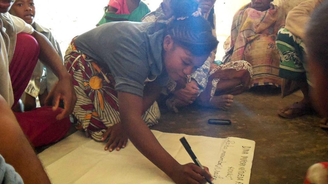
Community consultation to define the dina for governing mangrove use
After many consultations, both with the communities and with local government, the dina were finally submitted to the Regional Justice Department for revision and approval.
While all the work so far was done in offices and villages, the delineation of the zones required us to do some real field work in the mangrove forests themselves, where we were exposed to sticky mud and sharp-edged rocks under a scorching sun. Giving up was far from our minds however, as we were all determined to complete the objective of demarcating all the zones with paint every 50 metres.
 delineated in September 2015")
TAHIRY HONKO delineated in September 2015
 delineated in March 2016")
TOERA FAMBOLEA HONKO delineated March 2016
Within the 1500 ha mangrove forest, we helped the communities delineate 330 ha as permanent mangrove reserve, 210 ha of deforested areas for mangrove reforestation, with the remaining area zoned as sustainable forest management. A truly great achievement! But our story was still far from its end.
The next step was to convert the draft map created by the communities into a printed version with GPS points taken during the field work. Using GIS software, a new and more accurate map was produced and circulated in the villages.
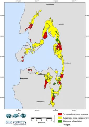
Map of mangrove management refined after the delineations
By the middle of 2016 we had started working on the more complex sustainable forest management zones. The start of this process was taking inventory of the forest, a task that took several weeks and involved collecting data on the number, size and species of trees within sample plots. We then progressed to a socio-economic survey, which collected data on the use of mangroves in the zones in order to calculate the number of trees that could be sustainably harvested by each household per year.
Results from this survey were disseminated during village meetings and workshops to gather the opinions of the communities regarding this tree harvesting quota. Anxiety about their livelihoods, mixed with their desire for conservation led to the communities expressing conflicting ideas. Some stated that the quota suggested was insufficient and others stated that it was excessive, and it ended up taking almost an entire year of patient discussions before the quota was finalised.

Mangrove wood | Photo: Garth Cripps

Fuelwood plantation | Photo: Ben Honey
This year (2017), we were overwhelmed by a couple of stirring achievements: a quota for wood harvested in the sustainable forest management zones was validated by the local communities, and the dina established for the permanent reserves and reforestation zones was approved by the Regional Justice Department.
On the 1st of June 2017, representatives from all ten villages, the Velondriake LMMA Committees, the Fisheries and Forestry Department, some local authorities, NGO partners and Blue Ventures staff all came to the village of Andavadoaka to validate the management plan for the Bay of Assassins’ mangroves. The entire management plan was laid out and discussed, and the debate was intense, but the results were promising. Everyone present agreed to establishing and enforcing the management plan. A book was produced to record the management plan, the regulations governing each zone, the monitoring system, and the penalties for infractions.
The management plan also included the promotion of alternative livelihoods such as beekeeping and fuelwood plantations. These alternative livelihoods help to promote the participation of women in mangrove management, and on International Women’s Day we saw a high proportion of women involved in reforestation events.

International Women’s Day in Befandefa saw 476 trees were planted by 112 people!

A woman plants a terrestrial tree in Befandefa
Looking forward, we’re excited to continue this journey to have the entire Tahiry Honko project reviewed and validated as the first Plan Vivo mangrove carbon project in Madagascar. This will certify that the communities are sustainably managing the mangrove forests which are sequestering carbon, and that the carbon credits can be marketed globally to organisations to offset their carbon emissions, providing sustainable economic benefit to the communities for conserving their mangrove resources in years to come
We would like to thank all the communities for their initiative, their engagement and their recognition of themselves as protectors of what they have established – I’m already looking forward to the next three years, and beyond!
We would also like to thank the Velondriake LMMA Committees, and to all the government representatives that have given their support.
Finally, we would like to thank the MacArthur Foundation, the Helmsley Charitable Trust, and the GEF Blue Forests project for their support of our Blue Forests initiative over this period.
Uncredited photos in this blog are by Cicelin Rakotomahazo, and the cover image is by Garth Cripps.