From BV volunteer Roger Vaughan, a retired teacher from California.
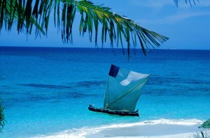
 Over the past few days I have had the opportunity to travel afield with BV staff members Lalao and Thomas, and volunteers Ben (U. Sheffield grad student), Ali (U. Montreal recent grad) and Ollie (just past A level in England). We left on a motorized pirogue early Friday morning and headed south for Lamboara and Tampolove. Ben and Lalao landed in Tampolove to begin work in monitoring mangrove forest health and eelgrass bed data collection. Thomas, Ali, Ollie and I met with the President Rahlehsah of the Lamboara Nehuda (Council of Elders) to start GPS mapping of traditional fishing areas around the two villages.
After lunch at the president’s home, he put us in touch with another Nehuda member, Fisherman Deelateh, who travelled with us in the pirogue to locate known fishing grounds on the reefs, and provide additional information about them. The gathered data will be used to develop maps for planning Marine Protected Areas, with the understanding and cooperation of the local fishing community.
 In the course of a wet and windy day we mapped 20 use areas, and managed a brief visit to the only identified turtle nesting beach in the area, which recently recorded a successful hatch of turtles. We saw the discarded egg shells from the hatch and were shown the remaining unhatched nest by the beach guard that BV and the local community has hired to protect the nest from egg-raiders (visit the BV site again soon for news on the progress of this second nest).
In the afternoon the crew returned to Lamboara where we had time for a walk through the local mangrove forest before being hosted for dinner and an overnight stay at the President’s home. Extremely low tides delayed departure for another round of mapping on Saturday, so there was time for another walkabout to visit the village wells, observe the daily work activities of the community (hulling rice, octopus fishing and mollusk collection in the tidal shallows,) and identify some local birds, including several lesser Vasa parrots, black and white forms of the dimorphic egret, and a Madagascar kestrel.
Once the tide was up enough, mapping continued in the areas closest to Lamboara. Rising winds made it impossible to reach all sectors of all fishing grounds, so a follow-up trip will complete the work in a few weeks. Returning to Lamboara for lunch, we found Ben returned from Tampolove with news that the mangrove data collection was under way and in good hands.
After lunch we all climbed aboard the pirogue to return to Andavadoaka. By this time the winds had kicked up high enough seas that we had to undertake a round-about route south through the Baie des Assassins and out to the open ocean beyond the waves at the barrier reef. Captain Thomas demonstrated his master seamanship, navigating the rough seas with ease. It was an exciting 3 hour ride that I would compare to river rafting at class 4, but without the rocks! Safely back at Andavadoaka, all hands cooperated to beach the pirogue above the high tide line before hurrying off to showers and dinner – lobster!!! A totally awesome 2 days.
