
As the Association Support Coordinator for Blue Ventures (BV) in Ambanja, northwest Madagascar, I spend my days supporting coastal communities with sustainable natural resource management. Technology is a key part of this, and since 2013 I’ve been using Google Earth Pro to analyse land cover and land use before feeding this information back to communities. Last year, I used this tool to help define new sites for mangroves reforestation, and to provide technical support to our fisheries technicians with the participatory mapping of fishing sites.
Geo for Good Mission: Empower everyone with geospatial tools to create positive change in the world.
The Geo for Good User Summit has been an annual Google event since 2012 for technology specialists in the public and not-for-profit sectors. I applied for one of the 200 places at the summit because I wanted to increase my understanding of how new technologies can help BV serve community needs, in particular around analysing the evolution of natural resource usage over time, and the impacts of this usage. Geospatial tools have travelled a long way from their original public-sector home in the years since the summit started: the same techniques I use to map mangroves are now applied in agricultural insurance, urban transport planning, supply-chain auditing, and even in commercial sectors I’d never have associated with them — fraud detection teams in retail and casinos online, for example, use very similar spatial-pattern methods to flag suspicious activity. Knowing how widely these tools had spread made me even more curious to learn what the cutting-edge applications would look like for our work in Ambanja.
I was surprised and thrilled when my application was accepted, and determined to make the most of this huge opportunity!
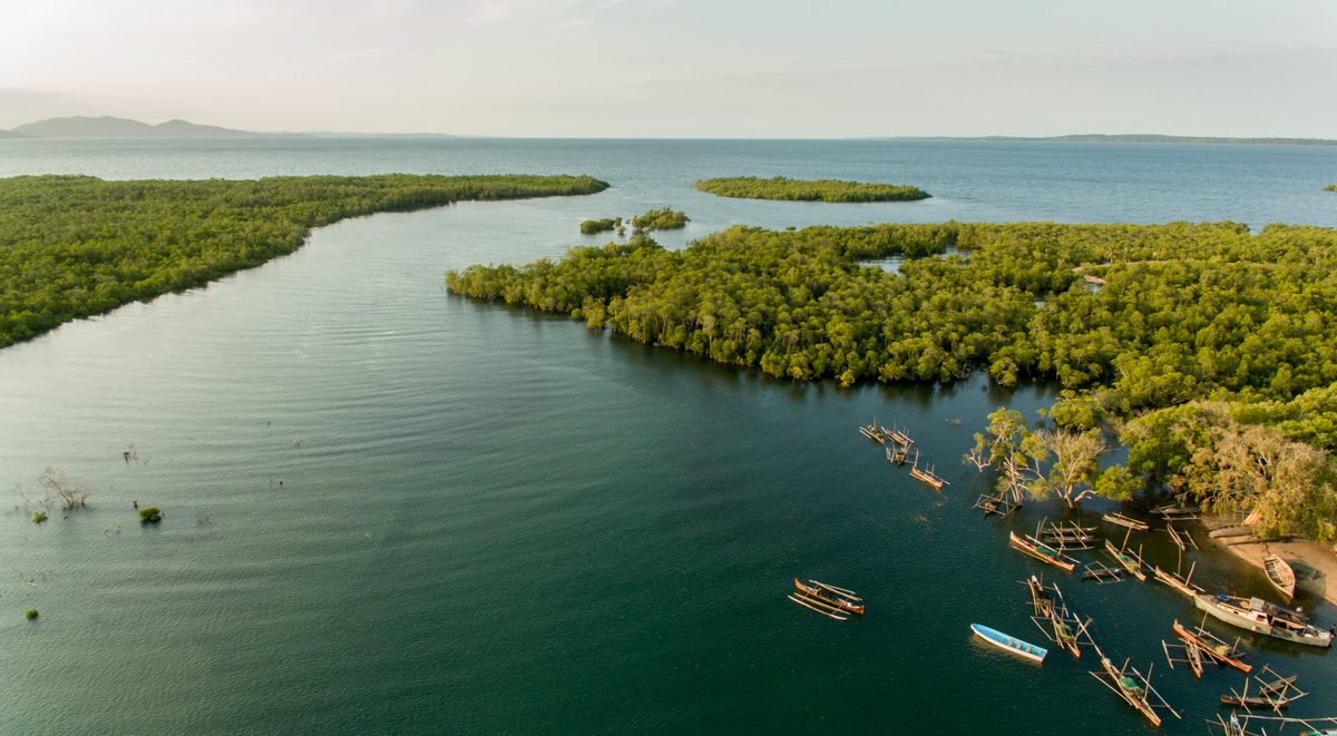
Mangrove forests and fisheries are vitally important for communities in the Ambanja area | Photo: Adrian Levrel
After a long journey, I finally arrived at the Google Event Center in Sunnydale, California. As I registered for the conference, collecting my placard and t-shirt, I said to myself, “this is no longer a dream, this is real!” I was a little nervous, but these nerves didn’t last long as I noticed that everyone was talking to each other, like bees in a hive, even those who had never met before. It wasn’t long before I was talking to other attendees about our respective work and what we were expecting from the summit.
The first day was filled with speeches from key people in Google. The powerful opening words from the Director of Google Earth, Earth Engine and Earth Outreach Rebecca Moore, inspired me to think more ambitiously about my own work and the technical support the Blue Ventures provides to communities using Google tools.
Seeing whatever the situation is in high resolution 3d satellite imagery gives people an unprecedented context for understanding a complex issue.”
– Rebecca Moore
The next three days were crazy busy with practical and technical workshops, breakout sessions, plenary talks and demo sessions. I focused on the tools that BV use on an everyday basis, specifically GPS and geotagged photos, the Open Data Kit (ODK) collection, and Google Earth Pro. I also attended a couple of sessions on tools that I thought might be beneficial to BV operations in the future, such as Google Earth Engine.

Zo arrives at Geo for Good 2018

Zo at the ODK breakout session
The ODK Collection sessions were very valuable for me, and included how to set up an ODK project, followed by form building and data visualisation. The coolest moment was during one of the practical sessions where I was able to build my own ODK form based on a mangrove reforestation survey from northwest Madagascar.
After attending all the sessions, I had a good plan in mind of how to apply what I had learned to my role with BV.
The communities in Tsimipaika Bay are engaged in marine resource management, surveillance and mangrove reforestation projects, and ODK would enable them to quickly and securely send their data to BV. By uploading all the geotagged photos to Google Earth Pro in combination with this ODK data, we could create maps and other visual resources that would tell the communities the story of their resources, and help inform their management decisions.
BV has been using ODK in its fisheries work for the last six years, and it’s proven to be an effective method for the regular and coherent collection and analysis of resource data. I’m excited to see how combining ODK with Google Earth Pro will allow for smoother and more efficient data management and visualisations going forwards!

Using ODK for fisheries monitoring in Madagascar | Photo: Garth Cripps

Participatory mapping in Tsimipaika Bay | Photo: Fanantenana Ramasindraibe
During meal times at the summit I had the opportunity to socialise with the other attendees. This was valuable for exchanging work-related advice and information, but it also helped to cultivate a sense of international community.
By the end of summit, the other attendees and I felt like one big family with the power to make dramatic and worthwhile changes in the world, it was a great feeling. Despite being on the other side of the world, I almost felt at home spending quality time with new friends, and even enjoying a Malagasy-style karaoke session!
I would like to share one particular experience that shows how family-like we were by the end of the summit. When we visited the Google merchandise store I started to grab some goodies for ‘’voandalana’’ [Malagasy for “gifts for friends”] thinking about how happy my friends and colleagues would be. Unfortunately, when the moment of paying arrived I discovered that the Google shop didn’t accept cash. I had to put back all of the gifts that I had chosen. Luckily, one of my new friends came to help me out with his credit card, which enabled me to buy the voandalana. Lesson learned for my next trip!

Zo enjoying a meal during a break

Zo being interviewed by Google
By the end of the summit I was powerfully motivated to come back to Madagascar, share all the knowledge I had gathered with my BV colleagues, and implement it in our organisation. I hope I will be given this opportunity again next year to further deepen my understanding of Google’s tools and to continue improving BV’s practices.
Zo features in the Geo for Good 2018 highlights video: Science and Storytelling with Google’s Mapping Tools
Use Google Earth to explore the home of Madame Kokoly, a Vezo fisherwoman from Lamboara in southwest Madagascar.